Cornwall flag
CornwallMagazine
Marystow

Marystow

Hamlet
PL16Torridge and Tavistock

Image may be sourced from Wikimedia Commons. If you know the original attribution, please suggest an edit.

16Listed Buildings

About Marystow

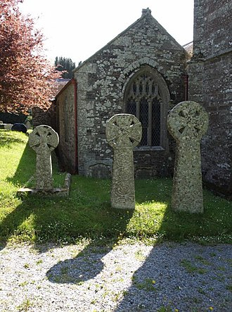
Marystow, also known as Stow-St. Mary, sits in the memory as a village and parish in the Tavistock district of Devon, England. Its double name hints at a layered past—Stow-St. Mary suggesting a quiet religious heritage, Marystow offering a shorter, affectionate form. Mentioned simply in records, the place invites the imagination: lanes once walked by parishioners, a community gathered around local life, and a sense of rural England caught between past and present. For the traveller who delights in destinations with stories behind their names, Marystow’s concise historical footprint is its appeal. There is something compelling about a place that exists largely through its name and its mention in district histories: an invitation to pause, to wonder, and to seek out the subtle traces that remain on the landscape. Whether encountered in a map, an old parish list, or a reflective journey through Devon’s Tavistock district, Marystow (Stow-St. Mary) rewards those who cherish the quiet resonance of history in place names.
Read more on Wikipedia →

Postcode

PL16

Constituency

Torridge and Tavistock

Ward

Bridestowe, Broadheath, Milton Ford, Tamarside

Coordinates

50.6235°N, 4.2145°W

Open in Google Maps →

Listed Buildings

CHURCH OF ST MARY

0.1 km
Grade I

ROBYNS CHEST TOMB ABOUT 6 METRES SOUTH EAST OF THE PORCH OF THE CHURCH OF ST MARY

0.1 km
Grade II

CHEST TOMB ABOUT 4 METRES SOUTH WEST OF THE PORCH OF THE CHURCH OF ST MARY

0.1 km
Grade II

COLE HEADSTONE ABOUT 12 METRES SOUTH EAST OF THE CHANCEL OF THE CHURCH OF ST MARY

0.1 km
Grade II

ROBYNS CHEST TOMB ABOUT 8 METRES SOUTH EAST OF THE PORCH OF THE CHURCH OF ST MARY

0.1 km
Grade II

COLE HEADSTONE ABOUT 13 METRES SOUTH EAST OF THE CHANCEL OF THE CHURCH OF ST MARY

0.1 km
Grade II

SYMONS HEADSTONE ABOUT 5 METRES SOUTH EAST OF THE PORCH OF THE CHURCH OF ST MARY

0.1 km
Grade II

ROSE CHEST TOMB ABOUT 4 METRES SOUTH EAST OF THE PORCH OF ST MARY

0.1 km
Grade II

PAIR OF SYMONS CHEST TOMBS ABOUT 5 METRES SOUTH OF THE CHANCEL OF THE CHURCH OF ST MARY

0.1 km
Grade II

PAIR OF COLE HEADSTONES ABOUT 14 METRES SOUTH EAST OF THE CHANCEL OF THE CHURCH OF ST MARY

0.1 km
Grade II

THE OLD VICARAGE

0.1 km
Grade II

BICKLE HEADSTONE ABOUT 7 METRES EAST OF NORTH AISLE OF THE CHURCH OF ST MARY

0.1 km
Grade II

PAIR OF MITCHELL CHEST TOMBS ABOUT 3 METRES NORTH EAST OF THE CHANCEL OF THE CHURCH OF ST MARY

0.1 km
Grade II

SUNDAY SCHOOL AND WALL AND GATES TO CHURCHYARD ADJOINING AT EAST

0.1 km
Grade II

LYCH GATE ABOUT 20 METRES SOUTH OF THE CHURCH OF ST MARY

0.1 km
Grade II

SYDENHAM MILL

1.0 km
Grade II

Nearby Places

C

Cornwall Guide

Ask me anything about Cornwall

Your local Cornwall expert. Try asking: