Middle Taphouse
HamletPL14South East Cornwall
Image may be sourced from Wikimedia Commons. If you know the original attribution, please suggest an edit.
5Listed Buildings
About Middle Taphouse
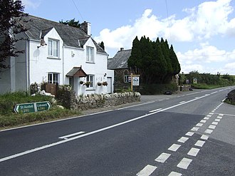
Tucked into east Cornwall, Middle Taphouse is a petite hamlet that feels like a quiet pause on the A390. About five miles (8.0 km) west of Liskeard, the settlement in postcode district PL14 is made up of a small group of bungalows and houses, framed by woodland. Hillball Wood rises immediately to the east, with further trees to the north, offering an immediate sense of green and shelter. Neighbouring hamlets and villages mark the route along the road: West Taphouse lies a little further west and the small village of East Taphouse sits further east, giving the area a pleasant ribbon of rural communities. Practical for visitors and locals alike, the Western Greyhound 575 bus service between St Neot and Liskeard stops at Middle Taphouse, linking it to the surrounding countryside of Cornwall in the South West. It’s an unpretentious slice of rural life—compact, leafy and quietly connected to the lanes and towns that surround it.
Read more on Wikipedia →Postcode
PL14
Constituency
South East Cornwall
Ward
Liskeard South & Dobwalls, Looe East & Deviock, Lynher, Lostwithiel & Lanreath, Liskeard Central, St Cleer & Menheniot