Chacewater
VillageTR4Truro and Falmouth, Camborne and Redruth
Image may be sourced from Wikimedia Commons. If you know the original attribution, please suggest an edit.
39Listed Buildings
About Chacewater
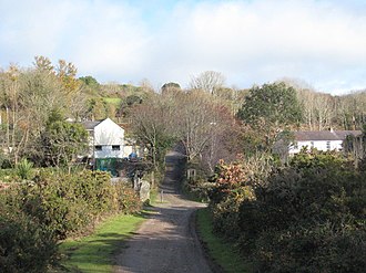
Tucked in the heart of Cornwall’s South West, Chacewater is a welcoming village and civil parish in postcode district TR4. It sits approximately 3 miles (4.8 km) east of Redruth, making it an easy point from which to explore the surrounding countryside. The parish is scattered with a handful of small, characterful hamlets — Carnhot, Cox Hill, Creegbrawse, Hale Mills, Jolly’s Bottom, Salem, Saveock, Scorrier, Todpool, Twelveheads and Wheal Busy — each adding its own quiet note to the wider community. At the 2011 census the parish recorded a population of 3,870, reflecting a village life that is pleasantly compact yet evidently lively enough to sustain a range of local settlements. Chacewater’s location in Cornwall offers a reassuringly rural base in the South West, where village rhythms and neighbouring hamlets combine to form a gently varied parish landscape. For visitors seeking a slice of Cornish village life within easy reach of Redruth, Chacewater provides an unassuming and authentic starting point.
Read more on Wikipedia →Postcode
TR4
Constituency
Truro and Falmouth, Camborne and Redruth
Ward
St Agnes, Gloweth, Malabar & Shortlanesend, Feock & Kea, Threemilestone & Chacewater, Probus & St Erme, Lanner, Stithians & Gwennap, Illogan & Portreath, St Newlyn East, Cubert & Goonhavern, Truro Tregolls, Truro Moresk & Trehaverne, Perranporth, Truro Boscawen & Redannick
Attractions
Chacewater Village
tourismChacewater is a village and civil parish in Cornwall, England, UK. As a programmatic destination page, it works well as a hub for nearby beaches, walks, heritage sites, food spots and local itinerary links across CornwallMagazine.
Dog friendlyvillagecornwalltourismlocal-area
0.0 kmWebsite