Jolly's Bottom
Other SettlementTR4Truro and Falmouth, Camborne and Redruth
Image may be sourced from Wikimedia Commons. If you know the original attribution, please suggest an edit.
4Listed Buildings
About Jolly's Bottom
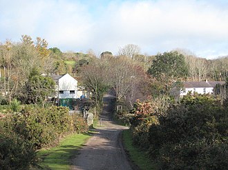
Tucked into west Cornwall, Jolly's Bottom is a small, quietly charming settlement that sits approximately half a mile (1 km) north of Chacewater. Part of the TR4 postcode district in the South West county of Cornwall, it gently straddles the main line railway, lending the place a sense of movement and connection to the wider region. Though compact, Jolly's Bottom feels like a pocket of calm where the rhythm of passing trains punctuates the Cornish air. Its location north of Chacewater makes it an easy-minded stopping point for anyone exploring the surrounding countryside, offering a glimpse of everyday Cornish life away from busier coastal hamlets. The settlement’s simple presence on the map is its appeal: understated, well placed and quietly rooted in the landscape of west Cornwall. For those seeking a modest detour that captures the steady heartbeat of rural Britain—railway lines, neighbouring lanes and the slow pace of village life—Jolly's Bottom provides a small, authentic slice of the region.
Read more on Wikipedia →Postcode
TR4
Constituency
Truro and Falmouth, Camborne and Redruth
Ward
St Agnes, Gloweth, Malabar & Shortlanesend, Feock & Kea, Threemilestone & Chacewater, Probus & St Erme, Lanner, Stithians & Gwennap, Illogan & Portreath, St Newlyn East, Cubert & Goonhavern, Truro Tregolls, Truro Moresk & Trehaverne, Perranporth, Truro Boscawen & Redannick