Gerrans
VillageTR2Truro and Falmouth, St Austell and Newquay
Image may be sourced from Wikimedia Commons. If you know the original attribution, please suggest an edit.
18Listed Buildings
About Gerrans
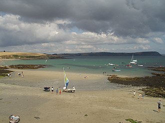
Perched on the Roseland Peninsula, Gerrans is a coastal civil parish and village that embodies the gentle pace of Cornwall’s east coast. Neighbouring Portscatho to the east, Gerrans offers a quietly confident presence on the peninsula, where lanes lead toward the sea and the landscape feels distinctly maritime. It sits approximately seven miles (11 km) south-southeast of Truro, making it an accessible retreat from the city while remaining tucked into the peaceful sweep of the peninsula. Located in county Cornwall within the South West region and carrying the TR2 postcode district, Gerrans is defined by its setting as much as its location: a village that sits alongside the water and alongside its closest communities. Visitors arriving from Truro will find Gerrans both easy to reach and delightfully removed from bustle, a place that promises the measured rhythms of coastal life and neighbourly ties with Portscatho on the eastern shore of the Roseland.
Read more on Wikipedia →Postcode
TR2
Constituency
Truro and Falmouth, St Austell and Newquay
Ward
St Goran, Tregony & the Roseland, Probus & St Erme, St Mewan & Grampound, St Stephen-in-Brannel, St Dennis & St Enoder, Truro Boscawen & Redannick
Attractions
Gerrans Coastal Village
tourismGerrans is a coastal civil parish and village on the Roseland Peninsula in Cornwall, England, United Kingdom. As a programmatic destination page, it works well as a hub for nearby beaches, walks, heritage sites, food spots and local itinerary links across CornwallMagazine.
Dog friendlyharbourcornwalltourismlocal-area
0.0 kmWebsite